Showing posts with label Appalachian trail. Show all posts

Sunday, October 16, 2016

Day 27: Hiawassee, GA. 2119.6 miles from Katahdin, 69.6 miles from Springer Mt.

To exemplify the ironic laziness of long-distance hikers, we rented a golf cart to do our laundry at our last stop, rather than walk a half mile round trip to the laundromat. The next day, we got up, scarfed down pancakes, and walked almost 18 miles on the trail. 
We were cruisin' towards Georgia and just had one more resupply, which we had already shipped to the Nantahala Outdoor Center, a white water kayaking and rafting destination right on the AT.
I had a great cheat planned that would cut out 15 miles of trail where the AT took a ridiculous bend, and another trail went straight across and connected. I was so pleased that my map (which Forrest does not think we need) was helping me outsmart the trail. Then I got a stomach bug. So, I walked to the nearest road and hitchhiked to town to rest. It is much less satisfying to outright skip days of trail due to being confined to a Holiday Inn Express than to sneakily skip parts on forest service roads.
Forrest marched on into Georgia without me-- I rode across the state line with a nice church lady whose good deed of the week was "rescuing" a pregnant lady from hitchhiking. Being in Georgia has already revealed two interesting facts: 1)chewing tobacco can be purchased by the half-gallon; and 2) my husband thinks that "Gone with the Wind" is an airplane movie.
We are shooting to make Springer Mountain before the week is out... We just have to keep our tobacco weight under control.

Tuesday, October 11, 2016

Day 22: Fontana Dam, NC. 2024.5 miles from Katahdin, 164.7 from Springer Mt.

What could be more fun than hiking the Appalachian Trail? Doing so in a hurricane. We hiked into Great Smoky Mountain National Park on the eve on Hurricane Matthew pummelling the east coast. It's long arms of wind and rain swept all the way to the Appalachian Mountains. We had a little bit of shelter from the storm, thanks to your tax dollars.
GSMNP is America's most visited National Park-- reporting 9.5 million visitors annually. Nine million of those visitors never leave what the National Park Service calls "the front country" and the lay person calls "the road."  (Imagine driving a carload of children to a huge playground and never leaving the parking lot. I know a few six-year-olds that would call that crazy, but that's how most Americans treat our park system.)
Even the "few" half million visitors annually that make it into the "back country" at GSMNP create quite an impact, so the park service insists that everyone concentrate camping to 3-sided shelters-- these were blessed protection from inches of rain and strong winds.
The Federal Government, in their wisdom, has also redirected funding from trail maintenance (which is atrocious on the AT in the park) to ensuring the few privies (outhouses) at said shelters are handicap "usable." The result is a pit toilet in a wooden box large enough for a wheelchair, complete with stainless steel lift bars and handles. You would never get a wheelchair down the miles of trails to these privies, but perhaps even more short-sighted is they didn't even outfit the stalls with ramps.
I only got to analyse a few privies,because of a long-standing Tennessee law forbidding outhouses. This law was apparently made ages ago to encourage people to convert to indoor plumbing, it's current practice results in thousands of people forced to camp and shelter in the same areas with zero waste management plan.
If the government didn't give us enough to think about, camping with packs of strangers certainly did. When it was raining, we were the only people in the shelter to hang our food bag from a tree (a method used to keep bears from eating you in your sleep while trying to get to your peanut butter). We concluded that most Americans would rather risk attack to themselves and their neighbors by large wild animals than get their backpacks wet.
The highest mountain in Tennessee is located in GSMNP: Clingman's Dome (6655'). This is also the highest mountain on the Appalachian Trail. It is adorned with an ugly concrete tower, and no other commemoration of the walker's lofty accomplishment besides recognizing, by all the crowds, that one could drive here. At least we know in our hearts that it's all downhill from here. Too bad walking downhill while pregnant is pretty difficult.
Within 2 weeks of accomplishing our goal, I stand by my original claim that hiking the AT while pregnant is not worse or harder than hiking last year, but it is slower. I also really miss Aleve, which I popped multiple times per day to ease sore joints and feet, but cannot safely ingest right now. However, the trail is a great escape from random people touching my stomach, a particularly irksome practice of our culture that has, thankfully, not transferred to the hiking community. It could be because I smell so bad, but, so long as we hang our food, I can travel through the woods unmolested.

Thursday, October 06, 2016

Day 16: Hot Springs, NC. 1914.8 miles from Katahdin, 273.7miles from Springer Mt.

Fewer than 300 miles to go, I have just entered my 3rd trimester, and, in my greatest coup to date, I am about to skip 33 miles of trail. The 3s are all lining up.
I made the mistake of picking up Forrest's pack at lunch the other day, just to move it. It was almost too heavy to lift, and only then did I realize how much of my gear he has sequestered into his pack. This guy can move uphill on rocks at a walking sprint; packs out every piece of litter he sees, even though his own pack is over-full; and, he is doing 100 push-ups per day because he is "not getting enough exercise" walking 16-20 miles daily. For these reasons, we both agreed I would take a day of rest while he stomps out an "easy" 33 miles in just over 24 hours.
The Appalachian Trail in the South is much easier trail than in the North-- less steep climbs and descents and better groomed trail, for the most part. We have been walking the spine of the Blue Ridge that separates Tennessee and North Carolina and are about to plunge into the Great Smoky Mountains, the country's most visited National Park and site of a continual eating competition between obese Americans and American Black Bears.
Forrest's pack belt keeps getting smaller and smaller, and mine keeps getting bigger. I
 get lots of entertaining reactions from other hikers when they notice my belly:  from squeals to "you are so brave" to "do you drink a lot of beer or are you pregnant?" 

Saturday, October 01, 2016

Day 12: Erwin, TN. 1846.3 miles from Katahdin, 342.9 to Springer Mt.

"I can't read, so I don't bother with signs." This is what our hitchhiking ride informed us as he drove us into town to buy supplies, where the TN/GA football game was on big screen and loud speaker at the Food Lion.
Every valley in this part of Tennessee is called a "hollow," but pronounced "holler." We've heard tales that each holler is occupied by a different family, usually feuding with the family in the next holler, Hatfield & McCoy style.
We are now picking our way along the Tennessee/North Carolina border, staying as far above the hollers as possible, except when we descend for supplies.
Fall is coming: the leaves are just beginning to change and the sky is raining acorns and chestnuts, one of which beaned Forrest, a direct hit from a mischievous squirrel.
As painful as the AT is, there are some redeeming qualities: the food, the kindness of strangers, and the appreciation it gives you for the overlooked. 
Hiking and camping for days, carrying everything you need with you, gives you a new appreciation for how wonderful a well-prepared meal is (like this one, at Mountain Harbour Hostel), or the luxury of a warm clean bed, conveniently elevated above the ground. Things we take for granted have again, after less than 2 weeks of hiking, become sources of joy-- maybe this is why many religions advocate fasting.
Appreciation of all the luxuries in our life, no matter how small, is something of which we all could use more. Today, as we trudge on, I will appreciate the ability to read.

Wednesday, September 28, 2016

Day 9: Roan Mountain, TN. 393 miles from Springer Mountain


Guess what the temperature is in the south in September? About the same as the South most of the time: hot with a side of humid. The locals keep threatening it will cool down, but probably not enough to make walking uphill with a pack less than sweltering.
Tennessee is chuck full of black bears and also chuck full of people and vacationers that see no reason to keep their food and trash far from the Bears. Generally, people don't want to be around hungry bears. But, if you continually feed animals, they will hang around-- look at dogs. Much of the Appalachian Trail in Tennessee struggles with so called "problem" bears and there are warnings and closures to hikers.
Since being in Tennessee, I have been convinced to buy "southern" hiking socks, crossed paths with a 5-foot black racer snake, stayed in the world's grossest hostel with 14 resident cats, and been bit in the leg by a tiny dog.
The only thing keeping me in this is my talent for cheating at long-distance exercise. With a few map reading skills, I am able to shave off a mile here or there while my partner diligently walks each and every step of the trail even faster than I can skip parts.
Forrest is carrying the majority of the load and spurring us onward to victory (or at least completion), and I am ready to move onward, at least to another state.

Saturday, September 24, 2016

Day 4: Damascus, VA 1719.9 from Katahdin, 469.3 from Mt. Springer

The human mind is amazingly forgetful. Women say childbirth is extremely painful, but then all sorts of people have multiple children. Well, I have been saying for the past year how painful and unpleasant the Appalachian Trail is, but was able to forget that enough to come out here again to try to finish. Guess what? It's as miserable as it was last time.
We are on the cusp on leaving Virginia and entering Tennessee. The last 60+ miles have been views of wild flowers and wild ponies, paved with wild rocks and wild roots. Our feet are blistering up and our appetites are growing.
I've changed a little bit of the hiking formula to accommodate being pregnant. First off, I got a "go for it!" from my OB doc, and a "proceed with cautionary measures" from my midwife. I'm hiking fewer miles per day (currently about 15), drinking a lot more water (thanks to a friend's hydration bladder I can just wear and drink from constantly), and wearing compression socks on my calves to help circulation. Downhills are even harder than they used to be, and downhills were never fun. The biggest difference is for Forrest-- if he sees me struggling, he takes my pack on his front (with double packs, going downhill with no view of his next footfall, he is still faster than I am).
I have to stop and pee about every mile. So, 469 more pee breaks and we'll be done.


Sunday, September 18, 2016

Back to the Trail... with a Free Rider

We are going to try it again-- the Appalachian Trail, that is-- Forrest would really like to finish what we've started.  I would just like it all somewhere so far behind me that we never discuss returning to it again. Our packs are lighter, as it is 82 degrees in Virginia right now, but I am heavier, as I am 6 months pregnant.
There really never was a better time to be pregnant, given the popularity of lycra-based pants and La Croix sparkling water. But, alas, I will be leaving these sweet commodities behind to again take up my pack.
We believe we can finish the last 530 miles to Mt. Springer in 35 days, so start your clocks. (I actually don't believe I can do it, and being a quitter is not something I am above.)

Friday, December 18, 2015

Day 97: Marion, VA. 1658 miles from Katahdin, 530 miles from Springer.

We got off the trail early! It's a Christmas miracle! The Greer Christmas celebration got moved up, so we are called from the rocks, roots & rain a couple days earlier than planned. 
We tromped, in the rain, of course, to the Mt. Rogers Visitor Center, about 40 miles shy of Tennessee, and laid down our trekking poles to travel to Florida like more reasonable people-- in a car.
We averaged over 17 miles a day, including our days off. Forrest took less than 6 days off from hiking. (I took a few more.) At our current pace, we need about 3 more weeks to reach the southern terminus. That's just not time we have right now. 
I'm heartbroken, as you can imagine, to start eating solid foods, and sleep in comfortable beds, and have more stimulus than rain on my face and leaves crunching underfoot.
I've learned lots of lessons over the past months, like: If you walk uphill for 6 straight miles, you won't be in Heaven, you'll just be tired. I imagine we'll be back to the last 500 or so miles, because you can't turn your back on this kind of education.
Meanwhile, Merry Christmas, God Bless, and keep your feet dry!

Wednesday, December 02, 2015

Day 81: Waynesboro, VA. 1327.5 miles from Katahdin, 861.7 miles from Springer Mountain

Our 108-mile hike through Shenandoah National Park started with the most spectacular sunrise I've ever seen, and then conditions devolved into fog, mist, and rain for days, ad nauseum. (I think there's an axiom to predict this:"red sky in morning...")
We knew that to stay dry at night, we would hike soaking wet as long as it took to get from shelter to shelter until we got to town or the rain stopped. The twist was that our friend Josh and his friend Bobby wanted to meet us and do a couple days of hiking.
If there is an easy way, or an entertaining way to get anywhere, Josh will always choose the entertaining way. So it was no surprise that his entry to the Appalachian Trail involved a rental car, an ill-fated supply run to a vegan grocery store, an argument with a ranger who said the park was closed, and bribing a dad with a van-full of kids to take back roads into the park. They found us by stumbling a mile in the dark, "saving their headlamp batteries," and fortified us with whiskey for the next rainy slog.
Bobby was too smart to hike in these conditions. He climbed back to Skyline Drive and found a ranger to drive him to the next shelter. Josh sloshed out 20+ miles with us. 
The one gear instruction I had given the boys on their way out was "bring rain gear and trash bags to waterproof your gear." The response I got was: "No s%*#, Sherlock." After the first day of long hiking, Josh pulled out a soaked sleeping bag and tried to dry it with the camp stove.
We were sick of rain and ready to get to town, but to get in striking distance as quickly as possible, we had to do an actual marathon: 26.2 miles, to get to a shelter close to town. Josh, limping from his 20-mile initiation and still damp from his night in a wet bag, said he was in. 
We started and finished in the dark, squishing out a total of 27.1 miles in one day. Josh entertained us with stories and kept up for every step of the Shenandoah Marathon. 
Josh & Bobby returned to Baltimore, Forrest and I made it to town, and all of us have renewed appreciation for roofs, hot showers, and non-vegan foodstuffs.

Friday, September 25, 2015

Day 14: Rangeley, ME. 220.4 miles from Katahdin, 1965.5 miles from Mt. Springer

Does hiking up and down the rock falls of a 4000+ foot peak at least once a day sound like fun to you? Ankle twisting, knee-popping, back-breaking adventures, for free? Come to Maine! 
The AT claims to have the elevation change equivalent of climbing Mt. Everest 16 times. Maine wants to get its share in. We have made it to what AT hikers call "Southern Maine" (it looks a lot like western Maine on a map). We are summiting steep peaks everyday, only to descend and do it again. Forrest has sprained both his ankles (he says he's "fine"). I have bent both my trekking poles, and mourned their wounds much more than Forrest did his own flesh.
We are pretty happy with our gear choices, except I have changed shoes. I went from a lightweight running shoe to something with a sole to combat the rocks and roots. Unfortunately, when you upgrade to a hiker sole, there's usually a waterproof feature. If you want to have wet feet at the end of the day-- wear waterproof shoes. Ask anyone who's ever worked in rubber boots.
We crossed the Kennebec River, which is the only assisted crossing (by canoe) on the AT. (All other rivers you just take off your shoes and wade.) 
After crossing the river, we joined the path that Benedict Arnold used to invade Quebec during the Revolutionary War back in 1775. One third of his troops deserted along the way, but we are still at full strength, probably thanks to more lightweight backpacking materials developed in the last 240 years. Oh, and maps.
We're 10% done. Onward to the infamous Mahoosuc Notch and the New Hampshire state line.

Saturday, September 19, 2015

Day 7: Monson, ME. 114.5 miles from Mt. Katahdin, 2071.4 miles from Mt. Springer


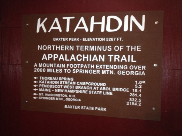
We made it through the gates: survived Mt. Katahdin & the "100 mile wilderness" and are headed south. We've hiked more than 120 miles, but you don't "count" hiking up Mt. Katahdin to the start. There are rules about counting, and a whole lingo that goes with this Appalachian Trail.

Mt. Katahdin
Katahdin/Mt. Baxter has the same identity crisis as Alaska's Denali/Mt. McKinley, but President Obama hasn't shown up here to announce to Mainers what they should be calling it. 
The way up & down this famous trailhead is more climb than hike, I realized as I had my elbows and knees wedged between boulders scrambling for every few feet.
Katahdin has been in the national news lately because the administration of Baxter State Park wants to move the trail's end from within their boundaries. The recently ticketed the recent AT record setter for being on the summit with a group larger than 12. When we were on the summit, there were more than 100 people there, drinking in the views on a gorgeous Saturday, many of them were smelly AT hikers, but many were day hikers. It seems to the casual observer that Baxter Park is just having a little turf war with the AT.

The 100 Mile Wilderness
The trail is marked with "white blazes" on trees and rocks. In the wilderness, in places, it seems that someone has just run through the woods with a paint can, randomly painting blazes, with no worry for the path between. We navigated rocks, roots, mud and more rocks. Maine has rocks. All sizes. 
We were accompanied by critters from toads, snakes and spiders, to moose and porcupine.
We've heard some great tales from northbound hikers, my favorite being from the German who claimed he was "in a bear attack." Upon further questioning, this meant that he talked to a guy who had his pack taken by a bear. We have seen a couple families on the trail. A mom & dad with 5 kids (youngest 9) summited Katahdin the day before us in 50 mph winds. They had hiked all the way from Georgia, homeschooling along the way. We crossed paths with a single mom hiking with her 11-year-old and twin 5-year-olds. They were a few days from Katahdin, also originating in Georgia.


Friday, September 11, 2015

And it begins

We are poised in Millinocket, Maine, about to head up Mt. Kathadin, the trail's famed "hardest climb" and Maine's highest mountain. It seems a little cheeky to me-- to "highpoint" a state when you've only known her a couple days. From Katahdin, we walk straight down into the "100 mile wilderness": the AT's longest stretch without re-supply. Normally routed, from South to North, most AT hikers hit these challenges after months of hiking, when they are at their toughest and fastest. We, on the other hand, can only brag relative cleanliness.
Everyone is shocked to hear that we are starting now-- in the winter?!?-- but we have 30 pounds of food packed and if we want lighter packs, we better start walking and eating.
We have heard that the peloton of Northbound hikers from the summer season is about two weeks south of us, poised to strike for their finish.
We stopped in Bangor to sing"King of the Road," pick up last minute supplies, and watch "Walk in the Woods": Robert Redford's new movie about Bill Bryson's attempt at the AT. Leave it to Nick Nolte & Redford to take a story about walking and make it rated R. But we got a lot of laughs headed in to an adventure that might need some laughter to carry us down the trail.